 FAO Map Catalog
FAO Land and Water Division
Type of resources
Available actions
Topics
Keywords
Contact for the resource
Provided by
Representation types
Update frequencies
status
Scale
-
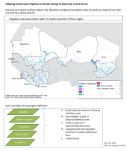
Broad typologies of irrigation systems in project countries were identified by analyzing distribution of area equipped for irrigation in relation to climatic conditions, (proximity to) water resources and coastline, and dominant land cover. The distribution of irrigation systems is derived from the Global Map of Irrigation Areas input files, but caution is needed as not all information is validated or updated. It is foreseen that the country level analysis will better refine this preliminary review. The land cover (FAO, 2014) input can help identifying valley bottom and wetlands where water is managed under no or partial control, most commonly found in humid and sub-humid climates. Proximity to (perennial) rivers and water bodies give an indication on whether the irrigation area is serviced by surface or groundwater, although caution is needed at this scale, as reliable information on irrigation infrastructures is not consistently available. Proximity to coastline and deltas are used to characterize irrigation areas which rely on coastal aquifers.